First, I just can’t spell Esplanade, it breaks my brain for some reason, so it should be called something else. I wasn’t able to attend the presentation of the plan, but have read the materials have a few thoughts. I am going to work through those thoughts in the based on the preferred plan’s segments. Everything is based on the existing designs which I recognize are “aspirational” at best.
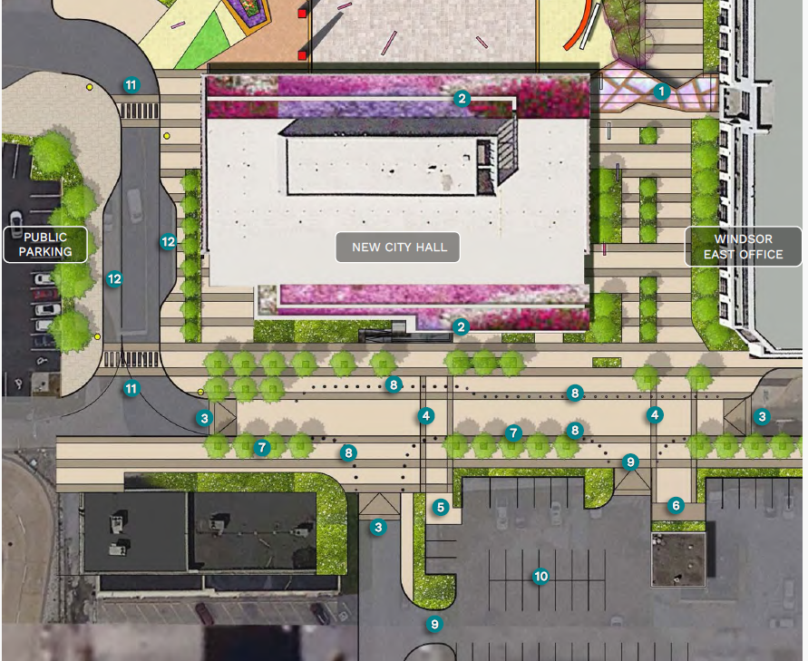
Segment 1a- City Hall Square South
For the most part this is dominated by Windsor’s favour feature, parking! As a new lot will replace the Councillor parking lot that exists behind the Tourism Office (number 10 on image below). The addition of a shade structure (1) connecting the two City Hall Buildings is a quality of life element for staff having to travel back and forth between them.
Streetscaping and narrowing (?) is also interesting but in some cases like between the East office and “New” City Hall it already exists, just visualized with more trees. Raising the entire segment of City Hall Square (street) to curb level and separating it from the “sidewalk” with lighted bollards is an interesting choice. Spots for bus parking outside City Hall is good as well.
I also wonder what is happening to 185 City Hall Square South (building in the bottom left of the image). This is owned by the City and currently has tenants – the budget for the operation of this building was set in 2022 Operations Budget. Other than some green imagery it isn’t included in this plan.
Segment 1b – City Hall Square North:
The north square crosses what is the existing greenspace where the former City Hall was situated. Many of the existing trees on the Northern end of the plaza (near University Ave) seem to be preserved, as is the existing Heritage Garden (18) and Cenotaph (3). The current City Councillor parking lot becomes the home to pavilion, seating areas, water feature, zamboni storage in the winter (more on that below) as well as new tree plantings that frame the exterior of the plaza footprint.
A new “Beacon” and gathering areas are the major feature next to the plaza (10) which will feature a food vendor pavilion. Obviously the question of who is this vendor and what do they serve is a big one. The other question will be, will it be licensed or not?
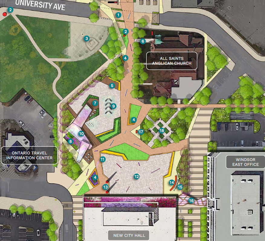
Media Screen (15) – Having a permanent media screen outdoors seem weird to me. What is the use case for that? Sure Jurassic Park style events or Library movie nights could be hosted in this plaza but how many days per year will that screen see use? Is the City going to use it as an ad revenue platform where it is just playing ads for lawyers in the plaza during the day – City Hall Plaza brought to you by Grey Monfort and Partners?
Skating Rinks – Three proposed outdoor rinks, with Zamboni and Storage facilities (8) in the North Square. All of the rinks are designed to prevent hockey from being played and none appear to be set up seasonal curling now that Roseland appears to be on the move. Who wouldn’t want an outdoor bonspiel in front of a lit up City Hall? I don’t skate, bringing skating back to City Hall and the downtown is important but I wonder how it connects to other plans. Is the food truck village (more on that in a minute) going to run in the winter? Are the seating areas and fire tables that illustrated going to be there? Sidenote: Fire-tables seem like a major liability issue for the city. What about Bright Lights?
Green Roof of City Hall – I actually don’t mind this idea, but my question is can the existing city hall structure take the green roof? It was not in the City Hall Presented Design that was eventually approved and constructed so I am curious on the impacts on the building of adding this feature? Do we want to risk creating a nesting ground for Geese who will hiss down on citizens coming and going from City hall?
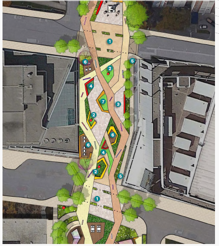
Segment 2 – Charles Clark Square
Charles Clark Square is currently largely just an empty space between two government buildings with a small cafe and sometimes a skating rink in it. The proposal would certainly transform and reanimate the space starting with an raised crossing (think really wide speed bump) on University ave connecting the City Hall Plaza.
Outdoor Work Area (5) – I am curious who is expected to be using these outdoor work stations? I don’t imagine court workers can do work outside? Are City Hall staff expected to walk over a block for an outside meeting? Seating and multi-use is good, but I question who, other than really municipal or other government workers are going to work in those spots? The University and College has common spaces in their buildings are students (who are not in class in the summer months) going to use it?
Food Truck Village (2) – One of the features of the Charles Clark Squire segment is a “food truck village” just off of University Ave. Now this is a good idea in principle, the problem is due to the existing Mobile Food Vendor By-law Food Trucks are Banned from the Downtown BIA (and all BIAs for the most part). Without a change in the by-law food trucks would not be able to operate in this area. Frankly I am supportive of removing the entire ban on food trucks from all BIAs but I image some restaurant owners feel otherwise.
I am also curious if these food truck spots are going to be revenue generators for the city or if they are be incubators for small businesses? The fee that is associated with parking a food truck in that “village spot” if any will determine if it is viable. As the food vendor requirements are expensive in their own right – Food Truck License $341, Criminal Record Check – $55, Safe Food Handling – $17, Business License (food services renewal) – $191. I would imagine various hook-ups – water, gas, drainage etc. could be in this “village” space, if they are never going to be used, why install them?
I think this is a interesting potential element that needs clarification if it is going to be included in the plan, otherwise it risks being a bait and switch situation where Food Trucks are promised in the designs but never materialize due to a policy and administrative barriers.
Segment 3 – Arts Park
This segment is a bit weird in my opinion as it is more transitionary than others IMO. Connect to Charles Clark Square by a raised road away with tree and planters “narrowing” the street with a path continuing towards the river front it is more of an art space. With various interactive and multi-media area installations as well as murals and other “installations”. This is one of the only segments were a specific bike path is mentioned,
The “gathering area” right outside the court house entrance is interesting as its location implies a waiting area for the Court. I guess it is too early to determine how much art will be local – but I would be supportive of that.
Segment 4 – Riverside Plaza
Between two apartment/condo buildings the Plaza portion (I think it is) of this segment sees a play area as well as leveraging some existing monuments. Again there is nothing really wrong with this, a play area is good but I wonder if there are many kids in the surrounding buildings to leverage the space?
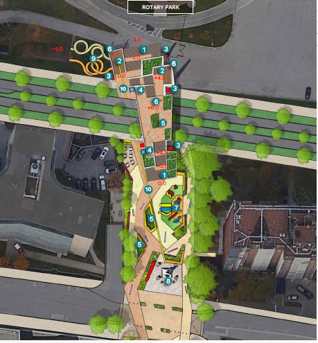
Segment 5 – City Beacon
The big question here is whether or not Riverside drive is narrowed with a central median and whether or not their is a bridge option. The renderings show only one lane of traffic with a central median going in each direction, the question would become, if that occurs, how far does it extend? Will the entire downtown see a narrowing of Riverside drive or just this section? A road diet can work, but the question is the logic of the diet. Narrow at Hiram Walker, widen for 10 blocks (ish), narrow at McDougall or so, widen at Ouellette, then narrow again at Carron is kind of crazy? The only funding related to Riverside Drive is ENG-002-14 which has to do with the retaining walls between Glengarry and McDougall – $1.75M starting in 2031.
The bridge option does give a nice lookout point that elevates over the Rotary Park, Detroit River as well as I would suspect a unique view up and down Riverside drive which is nice. I do think this would violate the by-law on height restrictions as the bridge crosses the road and terminates on the slope to the riverfront so waiving of the height by-law would be required and it is possible that a lower flow resident in the two apartment building could have their view of the river partially obstructed by the bridge if built.
A Few Other Things I noticed:
- No where in the proposed plan are mentioned any sort of bike infrastructure or docking/parking for scooters. There is a “Bike Path” that runs through Charles Clark Square to the Riverfront but not bike parking. Even squinting at the concept art, I could see spots to lock bikes that were intentionally designed.
- This plan would likely end the idea of the moving the Downtown Farmers Market back to this area. Given the size of the market and the number of features and levels being proposed in any given segment, I would doubt (although could be wrong) that the market could fit.
- Similar for moving Bright Lights in it’s entirety to this area. Currently Bright Light’s Covers approximately 91,000 square metres of space in Jackson Park vs the Esplanade which has approximately 11,800 square metres of space (including roadways) north of City Hall. Certainly it could spill on to the river front providing additional space and connectivity but it could also mean that it doesn’t move from Jackson Park due to logistics and other challenges like how you close of this area?
Costs:
Additional detailed costing should be available at the May 29th meeting of Council. If I ball parked this, I would imagine/guess the fully developed version of this plan with a bridge and skating rink is likely in the $25-35M range plus a decent annual operations/maintenance budget.
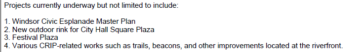
The current capital budget – item number PFO-003-15 held approximately $27 million dollars for Central Riverfront Improvement Plan & Civic Esplanade / Plaza. The keyword in this statement is the “AND” as this line from my reading also includes many of the other Riverfront Projects/Priorities:
Certainly this project falls in this envelop, the question becomes how does it come into synergy or conflict with other potential riverfront projects?
The second piece that needs to be considered is that almost $11M (fine $10,983,000) is held as money from the Federal Government. under the Canada Community Building Fund. As the City has a had mixed success in securing grant funding the last few years, is that a guaranteed sources of funding that we should be banking on?
Our riverfront has needs – lighting for example was proposed in the 2021 Budget but I do not recall much after that. This means that it was only improved from the Bridge to Randolph. There is exercise equipment planned from Riverfront – in 2030 – based on this year’s budget. The Street Car is getting installed at Caron Ave at the riverfront now, but other Beacons are few and far between. Then there is the Iconic Canopy which has an unknown status moving forward.
In theory all of these projects could be leveraging these dollars and a $30 million price tag is a big one when there are other major funding requests coming:
- Adie Knox Reimagining only has $10 million of the needed $27 Million committed (REC-002-21).
- Sandwich South Servicing Costs – this is almost 5-8% of these costs.
- University Ave re-imagining and redesign (that intersects this project) is not funded in the sections that this project would impact. Only one segment has been funded and $40 Million is outstanding outside of the current 10 year capital budget.
- Community Housing a number of major requests that could be expedited with these funds during a housing crisis.
Show me a budget and I will tell you what you prioritize.
Conclusion
I struggle to understand who is this project for? I am support of a major downtown investment, but is a plaza and esplanade the way to make that investment? If I am walking/biking along the river, why I am going to get off that trail and go to City Hall? If I live in one of the apartment buildings downtown, I am sure easier access to the riverfront is a boon. Are City Hall staffers itching to go for lunch time walks on the river and need a more direct path? If I am a University student at SOCA is this going to be a path I use? Sure the place will jammed-packed on fireworks night, but that is once day per year.
Across the City there are dozens of projects that are worthy of investment. This project is likely going to draw resources, use a limited number of grant applications, and take staff time and create ongoing operational costs – and hat assumes it moves forward without incident or issue. How does this connect to other activation or events? If the Streetcar Beacon is supposed to be an anchor on the waterfront (dubious at best IMO) why are we creating an alternative space off the waterfront? If the Festival plaza with canopy is supposed to host events and shows, why are we creating a food truck village and food vendor spots and plaza with media screen at City Hall? (My friend also asked me to hate on the streetcar and canopy. This is my hate).
It is all disconnected from one another, the result I fear will be disconnected spaces and underutilization.

As I recall Windsor’s transit master plan was also admittedly aspirational. Caroline Taylor.
Sent from Yahoo Mail for iPhone
Moving Bright Lights downtown doesn’t seem realistic unless they downscale it quite a bit. Perhaps they could have a few displays at all but Jackson Park is just easier to close off overnight.