The latest bugaboo in Windsor is around a wetland/woodlot/clumps of trees in Ward 10 ie. the South Cameron Woodlot and the surrounding lands. Just prior to the weekend the Mayor Dilkens celebrated the province removing the significant woodland/wetland designation, which would in theory allow for development. Social media has been a flutter with discussion condemning this development (pun intended) with a change.org petition calling for the green space to be protected having over 1,300 supporters in a few days.
The circumstances that lead to this debate are complex: City Council prioritizing flood mitigation and tree cover in their strategic planning sessions barely two weeks ago. At the same time the mayor’s celebration of the issue, one which was originally raise almost 2 months ago in the media as a development challenge for part of Windsor that will create new housing stock in the central part of the city and increase population density.
This isn’t the first time a woodlot has led to controversy in the face of development. Eagle nests were removed in Ward 7 in 2016, while Windsor’s Greek Community got into a spat with City Council over the removal of woodlot trees for their new Community Centre in 2014. The challenge that this sort of issue is that it twists people in knots. In many cases, as progressively minded individuals suddenly become NIYMBist and the hierarchy of priorities between infill development and environmental protection clash.
A facebook post by a resident of the area (wouldn’t embed properly) outlined many of the reasons why this change in designation could be seen as concerning. On face value I agree with author’s position, where I challenge her on this issue is that many of the points. Unfortunately she utilize are similar to those used by NIMBY advocates in major cities preventing density and affordable housing in affluent neighbourhoods: traffic congestion, little transit usage, changing the neighbourhood character by removing green space, there are “other areas” (brownfields) where this development could go. As I feel that twitter is the worst place to have a policy debate, I decided to unpack this issue a bit.
~paragraph above was edited
Density
Lets be clear, new housing will bring density and infill to the city. This area of the City is made up of 3 Census DA (codes: 35370339, 35370866, 35370867) with a total population of 5,556 spread over 1,611 private dwellings in 2.34 square km. As Don points out on twitter below:
If we take that 300 new units with the associated average family size of 3.8 people per dwelling, assuming they attract a similar socio-economic demographic it gives us approximately 1,200 people. The 1,200 people raises the population density of these Census DA from 2,374 people per km to 2,884 people per km in what would be high tax assessment new build constructions. It would actually lead to a overall population density of the ward by 52 per sq km to approximately 2,367.
We are not talking about thousands of new homes, and although there is a opportunity to bring more people with additional density in a potential new development (town houses as an example). As Ward 10 is the third least dense ward in the city, that’s not a bad thing.
Traffic/Transit
Another element of objection emerges from the already snarled traffic along Dominion and Northword. Traffic relief can emerge from connecting thoroughfares that currently service the area. Ojibway street connecting from Dayton Ave (one block of Huron Church) could be extended all the way to South Cameron. Kenora St. could run across Randolph all the way to Mark Ave. connecting Huron Church to Dominion. Mark Ave, could now bridge to Totten and suddenly Dominion and Longfellow are no longer the only North/South access to the area while creating a Northern drop off point for Holy Names School, albeit on the far side of the sports field.
Yes new housing would come with these streets, but it doesn’t mean that the whole woodlot is lost. A single row of housing along a connecting street is not a significant change in the density or populations but new roadway that can support both existing and new development would be created.
As for the lack of transit, there is nothing stopping residents in this area, the Dominion 5 runs through this neighbourhood. The reason why transit isn’t used in this neighbourhood is the same as the rest of the city: culture, convenience and perceived/actual poor quality of service. The solution to these problems are in my opinion, not impacted by whether or not new development goes onto these lots. In fact, the most effective way to ensure that transit usage would be to build affordable housing units. The unknown with this plan is whether or not affordable housing going into a middle income area would trigger its own NIMBY issues.
Development on Brownfield
As I have said on this blog, and something that I personally believe, the core housing stock in the central parts of Windsor (areas north of EC Row, more so north of Tecumseh) are fundamentally broken in the context of modern community need. Now certainly infill onto vacant and brownfield lands is desirable but in many cases in our city, they lack the economies of scale to be truly attractive to developers.
The question that has to be asked, is how big of a role do taxpayers want to play to incentivizing and subsidize developers into filling in missing teeth. The CIP with all of its success today is to be honest, corporate welfare to developers. The City is forgoing hundreds of thousands, if not millions of dollars in forgone taxes, fees and direct cash transfers to get developers to build in places that they wouldn’t build otherwise. Now I am not disputing the benefits of that development and the Downtown CIP has encouraged approximately 300+ units being proposed in the city core. This 50 acres of land would also support 300 units with a maximum development charges, zero tax abatement’s and all fees being collected.
Yes the woodlot is in the City’s Environmental Plan (take that at face value) but no one has discussed the fact that just because 300 units could be built, doesn’t mean that 300 units WILL be built. Even a developer can recognize the selling point of actually putting in less density, and leaving tree coverage/wooded areas. Don is right, the county is outbuilding the city and CMHC data shows that the county has build over 1,000 more detached home than the city over the last 5 years or so. If you actually want to tackle broader climate challenge, looking beyond “city sprawl” to “regional sprawl” is a logical jump that needs to be made.
Flooding
Flooding is an issue and there is no doubt that this area of Ward 10 has suffered:
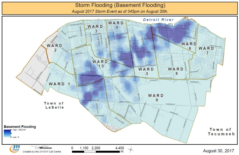
No infrastructure can handle catastrophic flooding rains of the past two years, there would have been flooding no matter what. Research by cityfloodmap.com which is written by Robert J. Muir, the Manager of Storm Water for the City of Markham Ontario finds that the rain events that occurred over the past couple of years are a statistically significant declining event based on older Environment Canada data. Now this isn’t to say that we won’t get these storms or downstream flooding nor that impacts from climate change won’t reverse this trend. In the same post, the following is stated:
Consider this: when your design standard is so low (Essex Region has the minimum 100-year flood standard in Ontario according to the Provincial Policy Statement on natural hazards), the importance of expanded development and intensification in existing development areas is an even more important factor when considering increased runoff and flood risk. Why? Because pervious land uses can absorb some fraction of ‘small’ 100 year storm but not much of the large storms used in other regions. Those using Hurricane Hazel design storms which saturate the ground with anecedent moisture conditions (US Soil Conservation Service AMC III conditions to be exact) do not have as significant an increase in runoff following development. Those using 100 year storm, like Essex Region, use the drier AMC II conditions in hydrologic models, meaning that the soil-vegetation surface can absorb relatively more … until it is paved over.
https://www.cityfloodmap.com/2016/10/windsor-and-tecumseh-flood-reporting.html
People should read a slidedeck about Markham flooding by the Robert, its pretty interesting. Modern development patterns have made flooding in these extreme rain events more likely regardless of infrastructure. What matters more is a combination of hydro-logical factors that I am not going to try and understand or explain here. Time, amount of water, how moist the soil is, elevation, soil composition, number of trees and plants that are around, etc. all play a roll in whether or not flood situations occur. Whether or not the existance of this woodlot would stop or mitigate future events given the surrounding residental make up is a question I can’t answer but we can’t assume is true.
The simplest of these factors is elevation and looking at this area of the City the woodlot area is actual high ground.
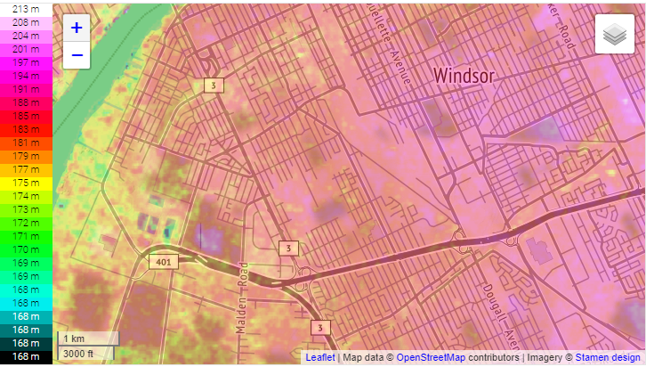
Although the change in height is only a few metres that is all water needs. In an extreme rain event, yes the woodlot would absorb rain but its also high ground and water is going to run in a surface and subsurface manner to the surrounding streets where municipal infrastructure can’t handle it.
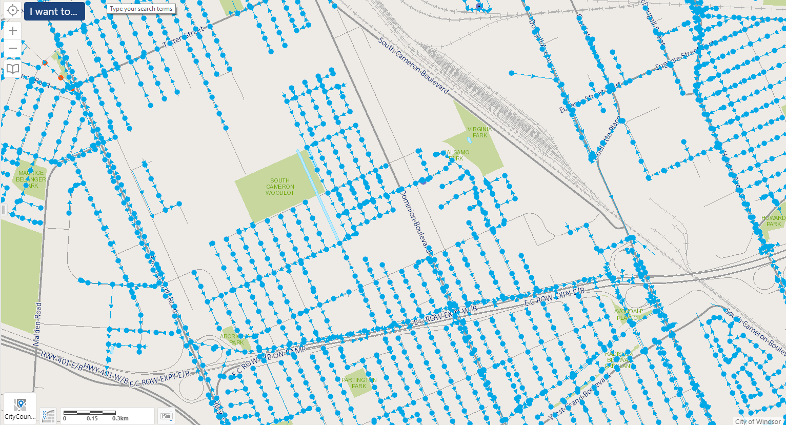
http://www.mappmycity.ca/Html5Viewer/Index.html?configBase=http://www.mappmycity.ca/Geocortex/Essentials/REST/sites/Sewer_Atlas_Upgrade_22/viewers/Viewer_HTML5_20/virtualdirectory/Resources/Config/Default
The above map shows is the storm sewer flow for the area of Ward 10. Almost all of the water that falls in South Cameron area flows south towards EC Row. This is the challenges when there is a historic rainfall in the areas downstream, there is no where for the water in and around South Cameron and Dominion to go, so it sits and ends up in basements.
A new progressively designed development actually creates an opportunity to build a relief value for this area. The fact that Dominion doesn’t have storm sewers according to this map is a joke to begin with, but a new east-west connector on some of the streets I mentioned above, with additional pumping capacity suddenly the upstream pressure to get water to ECRow is relieved. This coupled with an actual Dominion North/South storm sewer line may solve some of the problems better leaving all of the woodlot area intact.
This is Why Social Media Can’t Have Nice Things
The all or nothing nature of social media is why it is shit for policy debates, as it allows only all or nothing positions to be stated in the character limit. You can’t build here because I can only explain this one point; while the other side says you have to build as it is actually infill, is going to increase density and your a hypocrite for not recognizing it, debate rages in circles.
I think partially what happened here was a messaging issue, one that if you are conspiratorial may have been manufactured as future wedge. Mayor Dilken’s number one priority has consistently and to his credit been creating jobs and economic opportunity in the City of Windsor. Allowing this development to occur fits that mandate. The ask was put out to the premier and government (reported publicly in general terms) back in December. Given what we know now, I don’t know who is surprised that this provincial government came back with this approval.
The approval came from a government that could be generously called regressive on environmental (and other) issues, to a region that did not elect representatives to help form this government. I would be surprise if there were almost any announcement made by this government that would not create a vocal response from the local population against it.
Finally the inherent polarization in our community lingering over from the municipal election, a shift on council with high expectations for progressive change and a number of divisive issues circulating community meant that this announcement was primed for outrage, and that is what happened. This outrage rippled through Windsor relatively echo-y social media sphere painting a picture that 50 acres of trees and wetlands are in imminent risk of all being bulldozed and that the Mayor was plotting more flooding for Ward 10.
Personally, I don’t have a stake in this and I can see both sides. The fact is that any development going into the South Cameron area will have to be approved by City Council. There is nothing stopping a thoughtful and measured Council from approving development that will improve traffic access, sewer infrastructure and flood mitigation and preserve green space. There is a middle ground here, that brings more people to Windsor without negative repercussions to existing residents. Taking a breath and looking for that Win-Win is important.

Good review bit fails to address density options. The Mayor and some council still can only envision single family dwellings on separate lot as a way to grow the housing stock. With an aging population people will be looking to downsize. Condos and mixed use makes sense. Just look at The renewal of Woodward Ave in Detroit. There is no justification to use this Woodlot for housing. The Mayor is naive to think backroom deal with Ford are ever smart.
Hi Neil, Thanks for reading.
I agree there are lots of why to bring density into this space and others if it is at all. I assumed single family as the easiest and minimum standard of dwelling from a density standpoint that would be developed which allowed for an easy calculation. Having a wide selection of housing options for those who wish to downsize is important, whether or not that gets a development is another issue entirely.
Personally I try and avoid comparing to Detroit as the scale and forces at work are like comparing apples and orange in my opinion.
Dude. Try editing. Before you post. Sheesh.
Thanks for reading Mike.
I will strive to do better in the future.
Great post! I appreciate the thoughtful analysis. I particularly found the section on flooding to be enlightening. Thank you for writing it.
Pingback: A Few Thoughts on Week 39 | gingerpolitics