On Friday Mayor Dilkens shared an updated HAF proposal while standing in front of a map.

There is something interesting about this map on the left hand side – the orange area in the far western portion. Unfortunately I can’t find a high quality image of the map online but here is a better view from CBC.

These orange areas are called mixed use centres. The one that I am focusing on is the one that is on the old Windsor Race Track right next to a future Urban National Park. Now I suspect for many that when they think of National Park they do not think of a mixed use centre being right next door. From the 2022 Multi-Residential Interim Control Study we find this definition:

From Chapter 6 of the Official Plan we see this:

With in the Ancillary uses we see.
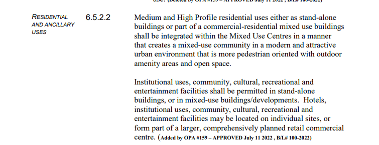
What do medium and high profile mean?
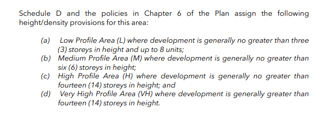
The key takeaways that that in this hub – low profile residential is not permitted and density and height requirements are not enforced. We are are talking about are buildings up to 14 stories next to a potential national park. The idea is to build a little “village” that is self contained commercial and residental along with amenities and other good built form.
From a zoning perspective the race track lands have been slated for some sort of commercial development. Looking at the plan from the same control study a zoning map showed that some commercial and resident has been planned. Across the road near Ambassador Golf course are already residential subdivisions.
As you can see above, residential (yellow) and commercial (purple) uses were identified in the areas zoning. The purple ends at Sprucewood Drive so it isn’t spilling into the existing residential.
Later in the same report we see this map which highlights where mixed use corridors and nodes are being targeted for intensification.

You will note the race track lands are not included. Back in December that changed during the special meeting of Council as you can see from the intensification map from the HAF proposal report. Notice the green areas covering north of Sprucewood.
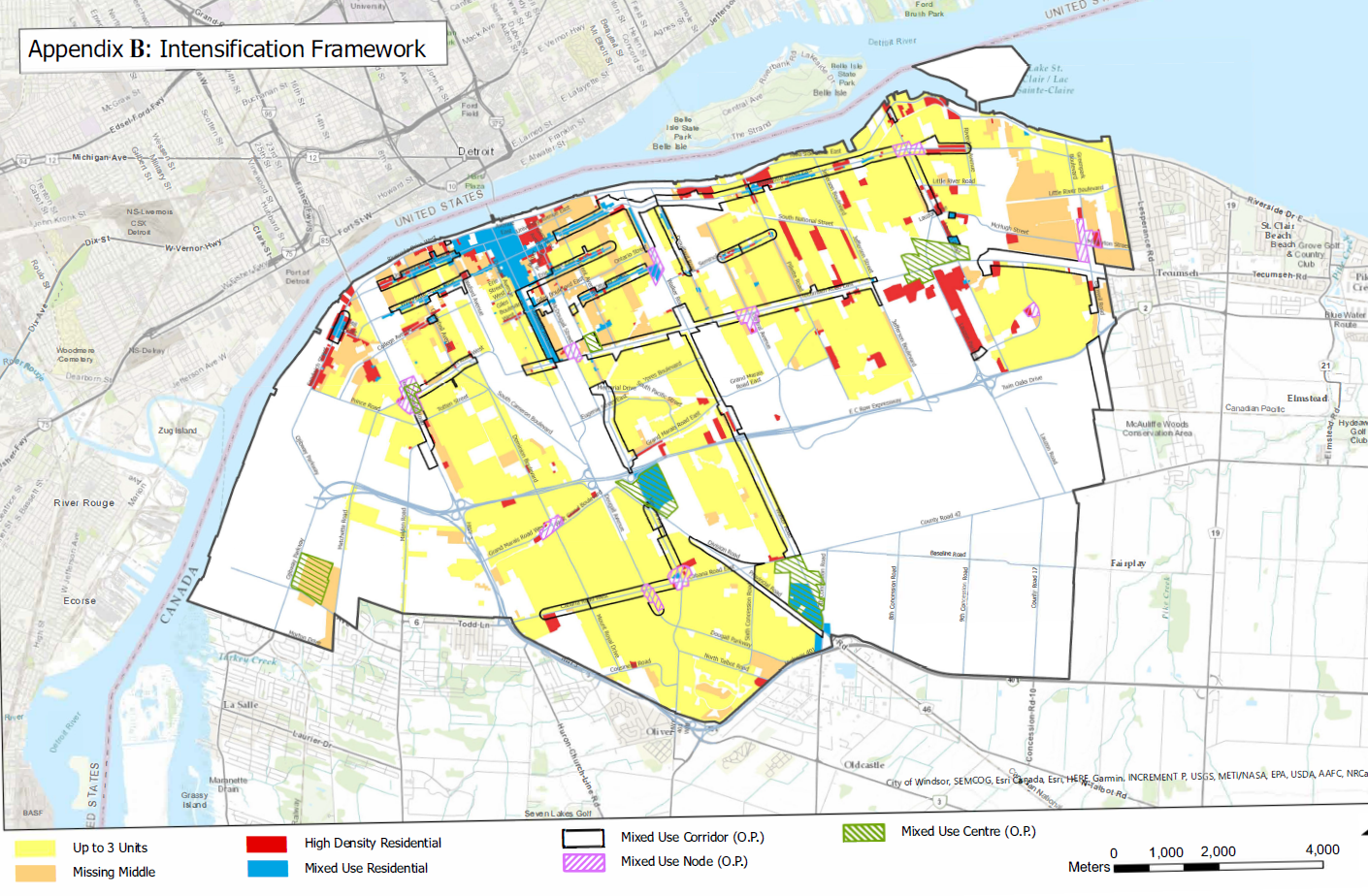
Suddenly the lands are included in the Mixed Use Centres you can also the orange “missing middle” classification applies to stretches of this land on the LaSalle border up Matchett Rd. Now maybe this change occurred previously, I am not sure, and I didn’t notice this until just this past Friday when I saw the map that kicked off this post shared but there are some big implications.
Implications
Right next door to an Urban National Park is being designated a mix use hub where missing middle housing is being target. Now from my understanding the raceway lands are not part of the Urban National Park study area. The fights over the environmental sensitivity of this area are well documented in the media.

Obviously there was some hope that the raceway if not developed could be added to the park. This new hub classification allow for high density zoning that I don’t think people equate with being right outside an urban national park in Windsor Ontario. A Starbucks and a 10 story Condo tower at Sprucewood and Matchett Rd – National Park View Condos – they practically sell themselves.
I would assume the race track likely needs significant servicing, the map below is from the City’s geospatial data (here) and shows sanitary and storm water sewer lines in the area.
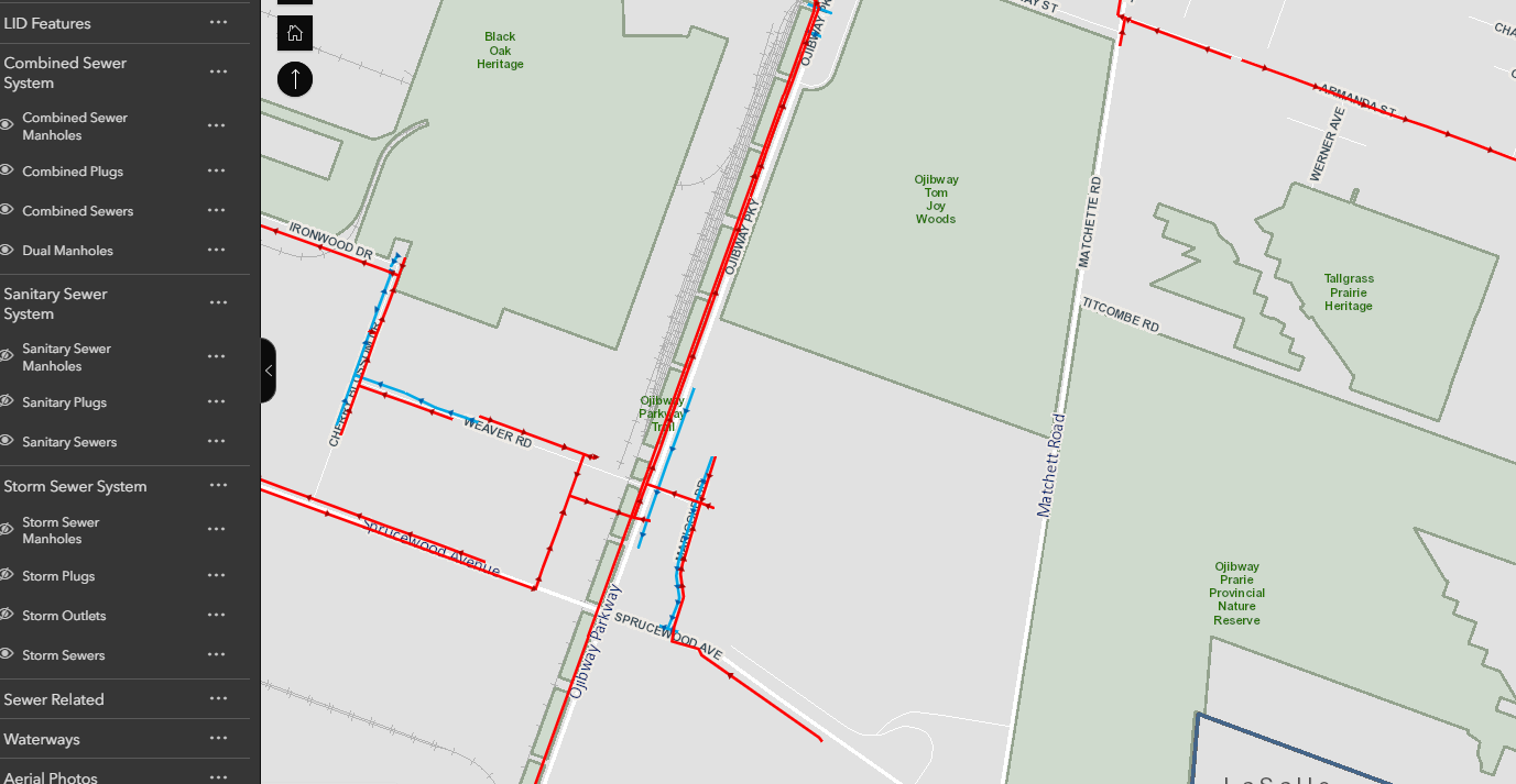
Currently the storm water sewers are disconnected and likely run off into creeks or naturalized areas while the there is a sanitary truck running down Ojibway Parkway. I am not in a place to know if it is appropriate to service a denser race track. Although the developer would be responsible for the site servicing but I am curious if the HAF funds could come in play here? If Ojibway sewers need to be updated, is this the sewer work that will be done? There are no services running down Matchett with open storm drains and ditches. So development on that side of the property will likely require pumping capacity to move it to the sewer trunks on Ojibway. Initiative #1 in the HAF proposal really speaks to this site by ensuring by-right residential development as well as potential incentives through intensification CIPs.
Finally what are the implications of this designation change had on land values? What was previously supposed to big box development and commercial is now eligible for medium/high density residential development. How does that change the value of this land? If Parks Canada wanted to buy and naturalize the old race track or even use it as part of the entrance (or parking lot) for the Park, how much has to price gone up by signaling this?
The closing or calming of Matchett Rd, as part of the National Park faces additional barriers if a true mixed use hub is going to the race track. Setting aside past threats of lawsuits, as the land values have gone up (as I suspect) the potential damages from constraining traffic flow to the land may have followed. If housing starts going up on this land, there is little chance that traffic and emergency service flow down only Ojibway Parkway into the City a second route will likely be needed.
Conclusion
Monday at council this is going to be discussed and decided – the plan proposes building 3,900 additional units by 2026 but not saying necessarily where those units will go. Many of us assumed Sandwich South with a few other units smattering through the City, but maybe not. Maybe on the far of the National Park a new hub is going to go in?
This flew under the radar in December for everyone, but now the potential interaction between this and the National Park process make Monday a very important day as this approval will then shape what kind of Park the Ojibway complex will be. It is possible I missed something and this was already settled, it might also be too late, the die may already be cast, but I hope there is a conversation about this and what kind of National Park we want.
